Residents across the Lehigh Valley and northwestern New Jersey are bracing for a significant severe weather event, as forecasters issue a Flood Watch in anticipation of widespread heavy thunderstorms capable of unleashing significant flash flooding.
The National Weather Service has issued the Flood Watch effective from Thursday afternoon through late night on July 31, 2025. This alert underscores the high probability of rapidly developing and intense precipitation that could quickly overwhelm drainage systems and low-lying areas, necessitating immediate preparedness measures from local communities.
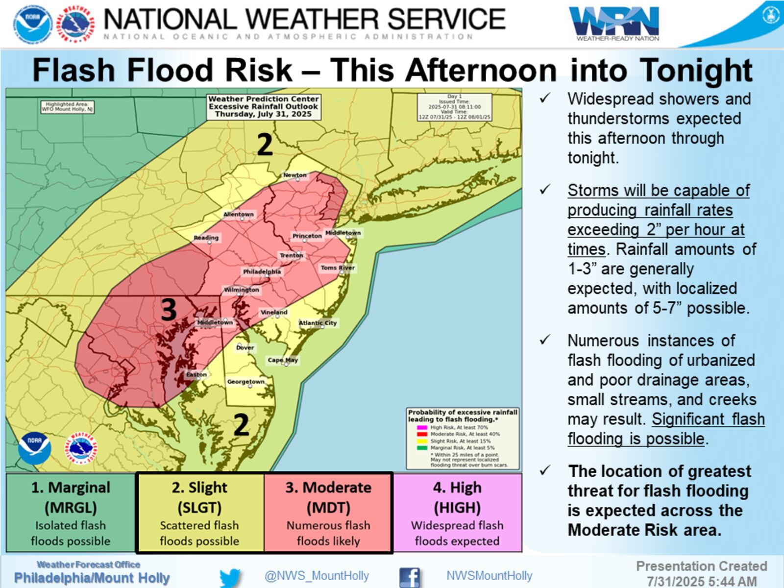
Current weather forecast models predict that these potent storms could dump substantial rainfall across the region, with localized areas in the Lehigh Valley and parts of northwestern New Jersey potentially receiving between 3 to 5 inches of rain. This concentration of precipitation within a short timeframe significantly elevates the risk of dangerous flash flooding conditions.
Meteorological analysis indicates a slow-moving cold front as the primary trigger for Thursday’s widespread showers and thunderstorms. This frontal system is expected to enhance rainfall rates, with some areas possibly experiencing over 2 inches of rain per hour. Such intense downpours contribute directly to the severe weather threat.
Beyond the immediate Lehigh Valley region, the broader Mid-Atlantic area is also under threat, with some sections facing potential rainfall totals of 5-7 inches from Thursday afternoon into Friday morning. These larger accumulations could lead to even more significant and widespread flash flooding, emphasizing a regional concern for public safety.
Before the arrival of these severe storms, residents will experience soaring temperatures, climbing into the upper 80s and low 90s, coupled with high humidity. These conditions will create heat index values well into the 90s, making outdoor activities uncomfortable and underscoring the contrast with the impending stormy weather.
Fortunately, the outlook for the upcoming weekend offers a welcome respite. A high-pressure system is anticipated to move into the region, ushering in much drier and more pleasant conditions. Saturday and Sunday are expected to feature comfortable temperatures near 80 degrees, significantly lower humidity, and delightful dewpoints in the 50s and 60s.
Post-storm, residents can look forward to clearer skies and a return to significantly more comfortable weather after the passage of the Thursday-Friday storm system. However, the immediate focus remains on heeding the storm warnings and preparing for the potential impacts of the heavy rainfall and flash flooding across both the Lehigh Valley and the affected New Jersey weather conditions.


Leave a Reply