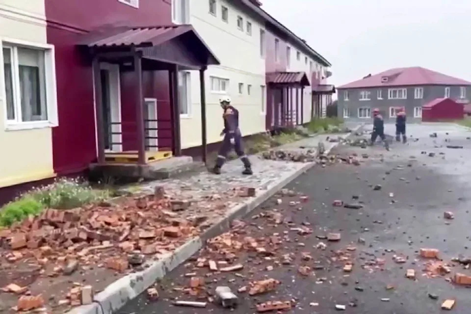
The powerful magnitude-8.8 earthquake off Russia’s Kamchatka Peninsula unleashed a colossal wave of water, propelling it across the Pacific Ocean at speeds comparable to a jetliner, triggering widespread tsunami warnings and concern from Hawaii to California and Washington state. Despite the initial alarm and the immense energy involved, the anticipated devastation did not materialize on U.S. shores, leading some to question the efficacy of the warnings. However, experts in Tsunami Forecasting and Earthquake Science unequivocally state that minimal impacts do not equate to inaccurate predictions, emphasizing the critical role of timely alerts in public safety.
Initial seismic reports underestimated the event, pegging the Kamchatka earthquake at magnitude 8.0 before an upgrade to 8.8. This significant revision highlights the immense power unleashed, with an 8.8 magnitude quake releasing nearly 16 times more energy than an 8.0. A crucial early indicator of the true scale was an initial measurement from a DART buoy positioned approximately 275 miles southeast of the Kamchatka Peninsula. These sophisticated deep-ocean assessment and reporting buoys are vital components of the global Tsunami Warnings infrastructure, providing real-time data on pressure changes indicative of passing Tsunami waves.
The swift and accurate response of Tsunami Modeling systems was paramount. Researchers, within mere hours, generated a comprehensive Tsunami Forecast for the entire Pacific, including detailed predictions of water levels for coastal tide gauges and potential flood inundation along U.S. coastlines. Vasily Titov, a key figure in developing the models utilized by the National Tsunami Warning Centers in Hawaii and Alaska, stressed that these models seamlessly integrate seismic data with the extensive network of over 70 DART buoys spanning the Pacific Rim, more than half of which are operated by the United States, showcasing a robust international collaboration in Coastal Safety.
Understanding Tsunami waves is crucial to appreciating the forecast’s accuracy. Unlike common wind-driven waves, Tsunami waves possess vastly greater energy, significantly longer wavelengths, and travel at incredible speeds across open oceans. Even seemingly small Tsunami waves, such as the approximately 2-meter waves predicted for Hawaii’s north shore, can pose extreme hazards, particularly in shallow waters where their energy compresses, causing them to surge dramatically and produce dangerous currents. This underscores why even a 1.5-meter (5-foot) wave can be profoundly dangerous.
The potential for inland surging, dangerous currents, and damage to marine vessels and other movable objects remains a significant threat from Tsunami waves of the size that impacted Hawaii. Despite the minimal overt devastation, these undercurrents and localized surges highlight the necessity of heeding tsunami alerts, which were indeed issued along the California coast, prompting evacuations and public warnings. The mere presence of people on balconies overlooking Waikiki Beach underscores the visual disparity between the perceived threat and the underlying scientific reality.
Historical context further validates the cautious approach. In 1952, a magnitude-9.0 earthquake struck off the Kamchatka Peninsula in a similar region, unleashing a devastating Kamchatka Tsunami on the town of Severo-Kurilsk, long before scientists fully grasped the intricacies of plate tectonics. This historical precedent serves as a stark reminder of the region’s seismic volatility and its capacity to generate destructive Tsunami waves.
The recent Pacific Tsunami was a classic example of a Megathrust earthquake produced along a large Subduction Zone fault, where one tectonic plate is forced beneath another. A similar, and potentially more dangerous, Subduction Zone exists off the coast of the Pacific Northwest, known as the Cascadia Subduction Zone. This fault line, running from Northern California to northern Vancouver Island, has the capacity to produce far larger quakes and, consequently, Tsunami waves that could reach heights of up to 100 feet, emphasizing the continuous need for advanced Seismic Activity monitoring.
Finally, the rapid arrival time of tsunamis generated by Subduction Zone earthquakes – often within 30 minutes to an hour – severely challenges forecasters’ ability to predict precise effects along the U.S. West Coast before inundation. This critical timeframe underscores the invaluable role of robust Tsunami Forecasting and early warning systems. The minimal U.S. effects from the recent Pacific Tsunami do not diminish the accuracy of the forecast but rather affirm the scientific models and buoy networks that provided vital, life-saving information, allowing for proactive measures that mitigated potential disaster.


Leave a Reply